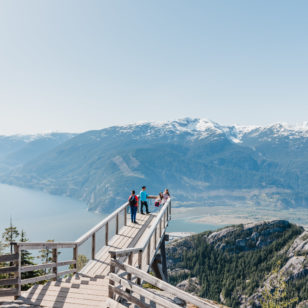
View from the first viewpoint. Photo: Taryn Eyton/HappiestOutdoors.ca
May can be a tough month for hikers. It’s nice and warm in the city, but the mountains are still covered in snow. That’s where great mid-elevation hikes like Diez Vistas come in. This trail near Buntzen Lake lets you get up high enough to enjoy some views but is low enough that you don’t have to worry about snow.
Until further notice, in line with the public health order, non-essential travel into, within, and out of BC is not recommended. BC residents, let’s do our part by continuing to stay small and support local with your immediate household, in accordance with the latest guidelines.
Safety First: AdventureSmart recommends bringing a backpack with essential safety and first aid gear on every hike. Check the forecast and pack extra clothing for the weather. Leave a trip plan so someone knows where you are going and when you will be back. Hiking is a little different during the pandemic. Read our tips for getting outdoors during COVID-19.
Trail Stats: Moderate, 15 km loop, 460 m elevation gain, 6-7 hours, dogs allowed on leash
Getting There: From Port Moody, take Ioco Road, 1st Avenue, and Sunnyside Road to Buntzen Lake Recreation Area. You can also take bus 182 to the park boundary and walk 2km into the park. (If you visit in July and August, bus 179 will take you all the way to the parking lot.)
The Trail: In Spanish, Diez Vistas means “ten views”. While the trail may have had ten viewpoints when it was originally built in the 1980s, today there are fewer as the trees have grown in. But the remaining look outs provide great vantage points of Buntzen Lake, Sasamat Lake, Vancouver, Deep Cove, and Indian Arm.
This moderately challenging loop is on the long side, so make sure you have the fitness to complete it. Some sections of trail are quite steep with technical footing, so hiking boots are a good idea.
During the pandemic, some trails at Buntzen Lake are one-way. As well, a rockslide has closed some trails. There are many trails in the area. Pay attention to trail signs, use the park map and this trail description to complete the hike.
Find the trailhead at the southwest corner of the parking lot (at the opposite end from the beach). Follow the trail through the trees to a floating bridge over the lake outlet, ignoring all side trails. Once you get across the bridge, head straight and take the Diez Vistas Trail uphill.
You’ll gain the bulk of the hike’s elevation gain over the next two kilometres. Stay on the trail and it climbs through the forest. About halfway through the climb, emerge into an open area with a powerline crossing. The trail gets even steeper from this point, with several switchbacks.
As you near the top, enjoy the views of Sasamat Lake with Burnaby and Vancouver in the background. Continuing upward, follow a side trail to the right to East Point. It has a great view of Buntzen Lake far below you.
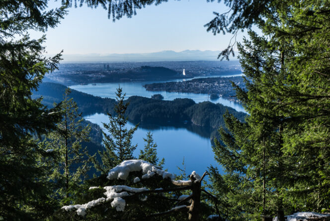
Continue along the main trail as it follows the top of the ridge. Soon you’ll arrive at a great viewpoint looking down on Indian Arm and across to Deep Cove. As you hike further along the trail, you’ll pass more views of Indian Arm, but the first one is the best.
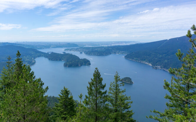
View of Indian Arm and Deep Cove. Photo: Taryn Eyton/HappiestOutdoors.ca
After the viewpoints, the trail continues along the ridge as it slopes downhill, gradually at first, but more steeply towards the bottom. About 7.5 kilometres from the trailhead, reach a gravel road. Turn right and walk along it for a few minutes to the junction with the Old Buntzen Lake Trail.
Turn right and follow the Buntzen Lake Trail along the western shore of the lake. (You must turn right here as the Buntzen Lake Trail is open for counter-clockwise travel only AND the east side of the trail is closed due to a rockslide.)
The first section of trail along the lake follows the powerlines, then heads into the forest on an undulating trail that crosses pretty little streams on wooden bridges. The trail descends back to lake level at the pumphouse. From there, follow a gravel road along the lakeshore back to the floating bridge to complete your loop hike.